The San Francisco Bay Area is blessed with an incredible diversity of landscapes, from dramatic Pacific coastlines to towering redwood forests, rolling wine country hills, and panoramic mountain vistas. These scenic drives offer some of the most breathtaking views in California, making them perfect for day trips, photography excursions, or simply escaping the city for a few hours. Here are the top 10 scenic drives near San Francisco.
Route: San Francisco to Big Sur (approximately 150 miles) Highlights: Bixby Creek Bridge, McWay Falls, Point Lobos, Pfeiffer Big Sur State Park Drive Time: 3-4 hours one way Best Time: Year-round, but spring and fall offer the best weather
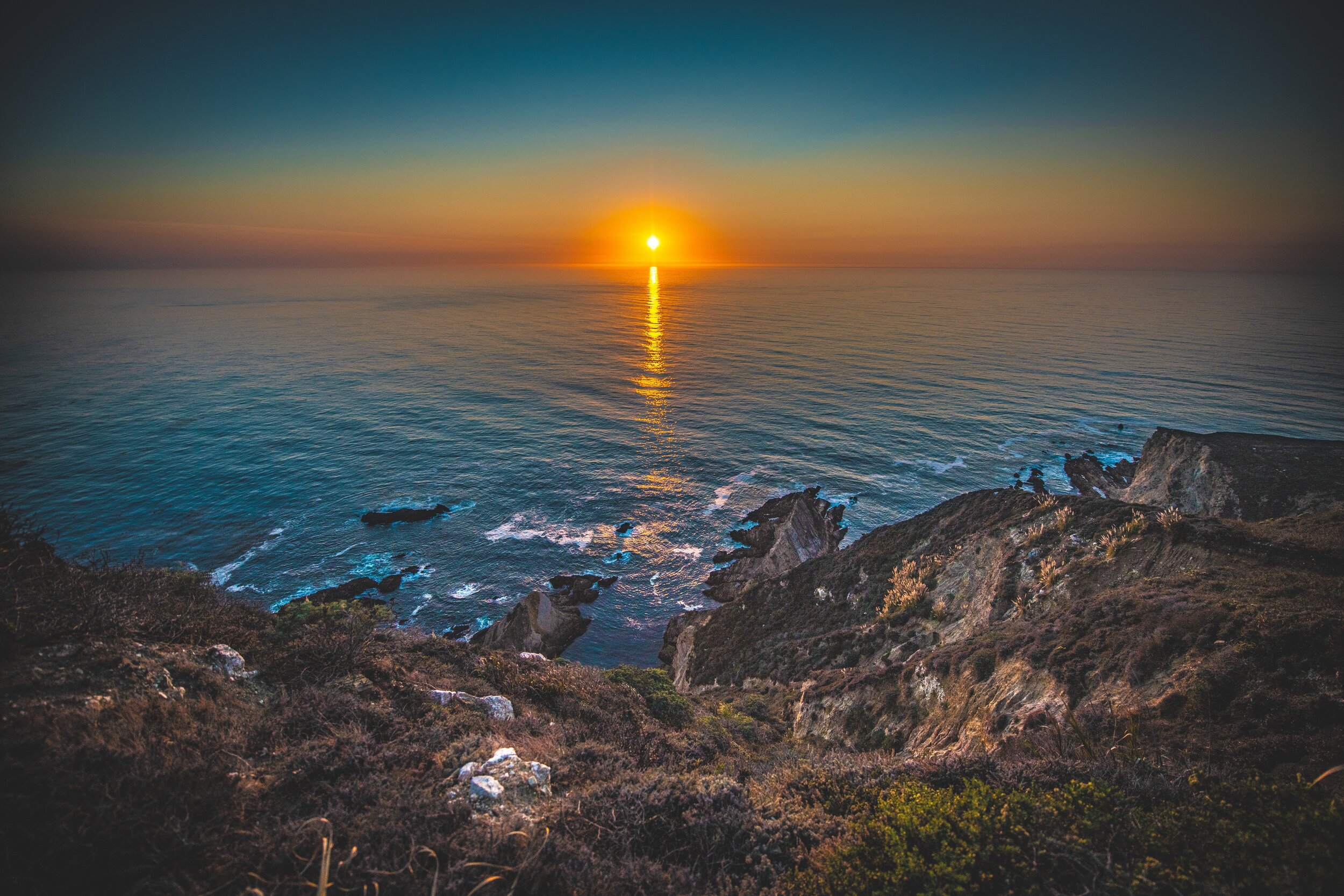
Why it's top: The drive from San Francisco to Big Sur along Highway 1 is one of the most iconic scenic drives in the world. This route offers dramatic coastal cliffs, pristine beaches, and some of California's most photographed landmarks. The journey takes you through charming coastal towns, past historic lighthouses, and along winding roads that hug the Pacific coastline.
What to expect: Stunning ocean views, dramatic cliffs, the iconic Bixby Creek Bridge, McWay Falls (an 80-foot waterfall that cascades onto the beach), and numerous scenic turnouts. The drive includes stops at Point Lobos State Natural Reserve, Garrapata State Park, and Pfeiffer Big Sur State Park. Be prepared for winding roads and potential fog, especially in summer months.
Best for: Coastal photography, ocean lovers, and anyone seeking one of California's most famous driving experiences. Perfect for a full-day trip with multiple stops.
Note: Check current road conditions before traveling, as sections of Highway 1 near Big Sur can experience closures due to landslides.
Route: Runs along the ridge of the Santa Cruz Mountains Highlights: Castle Rock State Park, Silicon Valley Vista Point, redwood forests Drive Time: 1-2 hours Best Time: Year-round, with fall colors in autumn
Why it's top: Skyline Boulevard offers panoramic views of both the Pacific Ocean and San Francisco Bay from the ridge of the Santa Cruz Mountains. This elevated route provides a unique perspective of the Bay Area, with views stretching from the ocean to the bay. The drive is lined with towering redwoods and provides access to several parks and preserves.
What to expect: Sweeping panoramic views, redwood forests, access to Castle Rock State Park and other natural areas, and the Silicon Valley Vista Point offering views of the entire Bay Area. The road winds through mountain forests and offers numerous pullouts for photography and sightseeing.
Best for: Those seeking elevated views of the Bay Area, redwood forest enthusiasts, and photographers looking for panoramic perspectives. Great for a half-day drive with hiking opportunities.
Route: Mill Valley to Mount Tamalpais State Park (13 miles) Highlights: Mount Tamalpais, redwood groves, East Peak views Drive Time: 30-45 minutes, plus time for stops Best Time: Year-round, with clear days offering the best views
Why it's top: Panoramic Highway winds through Mount Tamalpais State Park, offering some of the most beautiful views in Marin County. The drive takes you through valleys filled with redwood trees and Douglas firs, ascending to the East Peak of Mount Tamalpais at 2,572 feet. The route provides stunning views of the Bay Area, Pacific Ocean, and surrounding valleys.
What to expect: Dense redwood and Douglas fir forests, winding mountain roads, views from Mount Tamalpais East Peak, and access to numerous hiking trails. The drive offers a peaceful escape from the city with relatively light traffic compared to Highway 1.
Best for: Mountain scenery lovers, hikers seeking trail access, and those looking for a shorter scenic drive close to San Francisco. Perfect for combining driving with hiking.
Route: Napa to Calistoga (29 miles) Highlights: Vineyards, rolling hills, wine country views Drive Time: 45-60 minutes, plus time for winery stops Best Time: Spring through fall, with harvest season (September-October) being particularly beautiful
Why it's top: The Silverado Trail runs parallel to the busier Highway 29 along the eastern edge of Napa Valley, offering a more serene and scenic route through wine country. This less-trafficked road provides beautiful views of rolling hills covered in vineyards, with the Mayacamas Mountains as a backdrop. The route connects Napa to Calistoga, passing numerous wineries along the way.
What to expect: Endless rows of vineyards, rolling hills, mountain backdrops, and access to world-class wineries. The drive is particularly beautiful during harvest season when the vines turn golden, and in spring when the vineyards are lush and green. The road is well-maintained and offers numerous opportunities to pull over and enjoy the scenery.
Best for: Wine country enthusiasts, those seeking a peaceful drive through beautiful countryside, and visitors looking to combine scenic driving with wine tasting. Perfect for a leisurely day trip.
Route: Marin County through Samuel P. Taylor State Park to Point Reyes Highlights: Old-growth redwoods, Point Reyes Lighthouse, coastal views Drive Time: 1-2 hours, plus time for stops Best Time: Year-round, with spring wildflowers and fall colors
Why it's top: Sir Francis Drake Boulevard offers a diverse scenic experience, taking you from Marin County through old-growth coastal redwood forests in Samuel P. Taylor State Park to the historic Point Reyes Lighthouse. The drive combines forested areas with coastal views, providing a complete Northern California landscape experience.
What to expect: Dense redwood forests in Samuel P. Taylor State Park, winding roads through forested canyons, and eventually opening to coastal views near Point Reyes. The drive includes access to hiking trails, the Point Reyes National Seashore, and the historic Point Reyes Lighthouse. The route offers a peaceful, less-crowded alternative to Highway 1.
Best for: Redwood forest enthusiasts, those interested in combining forest and coastal scenery, and visitors to Point Reyes National Seashore. Great for a full-day trip with multiple stops.
Route: Loop through San Francisco (49 miles) Highlights: Golden Gate Bridge, Golden Gate Park, Chinatown, Fisherman's Wharf, city views Drive Time: 2-4 hours with stops Best Time: Year-round, with clear days offering the best views
Why it's top: The 49-Mile Scenic Drive is a historic route designed to showcase San Francisco's major attractions and diverse neighborhoods. While primarily an urban drive, it offers glimpses of the city's coastal scenery, iconic landmarks, and varied architectural styles. The route winds through the city, connecting major attractions and offering views of the bay, ocean, and city skyline.
What to expect: Views of the Golden Gate Bridge, access to Golden Gate Park, drives through Chinatown and Fisherman's Wharf, coastal views along the Great Highway, and panoramic city vistas from various hills. The route includes both urban and natural scenery, making it unique among scenic drives.
Best for: First-time visitors to San Francisco, those seeking to see the city's highlights in one drive, and anyone interested in urban scenic routes. Perfect for combining sightseeing with scenic driving.
Route: Woodside to Highway 1 via Skyline Boulevard (approximately 15 miles) Highlights: Redwood groves, mountain views, coastal descent Drive Time: 45-60 minutes Best Time: Year-round, with spring and fall being particularly beautiful
Why it's top: This narrow, winding route offers a dramatic transition from redwood forests to coastal views. Starting from Woodside, Kings Mountain Road ascends through redwood groves, crosses Skyline Boulevard, and descends as Tunitas Creek Road toward Highway 1 and the Pacific Ocean. The drive provides a complete landscape experience from forest to coast.
What to expect: Dense redwood forests, winding mountain roads, elevation changes, and eventually opening to coastal views. The road is narrow and winding, requiring careful driving, but offers a peaceful and scenic alternative to busier routes. The descent toward the coast provides dramatic views of the ocean.
Best for: Experienced drivers comfortable with narrow, winding roads, those seeking a forest-to-coast experience, and photographers looking for diverse landscapes. Great for a half-day drive.
Route: East San Jose to Mount Hamilton summit (approximately 19 miles) Highlights: Highest point in Bay Area (4,062 feet), panoramic valley views, Lick Observatory Drive Time: 1-2 hours, plus time at the summit Best Time: Year-round, with clear days essential for views
Why it's top: Mount Hamilton Road ascends to the highest point in the Bay Area, offering panoramic views of the Santa Clara Valley and surrounding wildlands. The drive features numerous twists and turns as it climbs to 4,062 feet, passing through diverse landscapes from valley floor to mountain summit. The route ends at the historic Lick Observatory.
What to expect: Steep, winding mountain road with numerous switchbacks, elevation gain from valley to summit, panoramic views of the Santa Clara Valley, and access to the Lick Observatory at the summit. The drive offers a dramatic change in elevation and scenery, with views improving as you ascend.
Best for: Mountain driving enthusiasts, those seeking elevated panoramic views, and visitors interested in astronomy and the Lick Observatory. Perfect for a half-day trip with summit exploration.
Route: Through Redwood Regional Park Highlights: Dense redwood forests, peaceful forest drive Drive Time: 30-45 minutes Best Time: Year-round, with morning light filtering through redwoods
Why it's top: Redwood Road offers a peaceful escape from city life, cutting through Redwood Regional Park's dense redwood forests. This route provides a serene drive through some of the East Bay's most beautiful natural areas, all within close proximity to urban Oakland. The drive offers a quick nature escape without leaving the Bay Area.
What to expect: Dense redwood forests, peaceful forested drive, access to hiking trails, and a sense of being far from the city despite being in the East Bay. The road winds through the park, offering glimpses of towering redwoods and forested canyons.
Best for: Those seeking a quick nature escape, redwood forest enthusiasts, and East Bay residents looking for nearby scenic driving. Perfect for a short drive combined with hiking.
Route: Golden Gate Bridge to Point Reyes (approximately 50 miles) Highlights: Marin Headlands, Stinson Beach, Point Reyes National Seashore Drive Time: 1.5-2.5 hours, plus time for stops Best Time: Year-round, with spring wildflowers and clear fall days
Why it's top: The drive north from the Golden Gate Bridge along Highway 1 offers stunning coastal views, access to the Marin Headlands, beautiful beaches, and eventually Point Reyes National Seashore. This route combines dramatic coastal cliffs, sandy beaches, and the unique landscape of Point Reyes. The drive provides numerous opportunities to stop and explore.
What to expect: Views of the Golden Gate Bridge from the Marin Headlands, coastal cliffs, access to Stinson Beach and other beaches, and eventually the unique landscape of Point Reyes with its tule elk, historic lighthouse, and dramatic coastline. The drive offers a complete Northern California coastal experience.
Best for: Coastal scenery enthusiasts, beach lovers, and those interested in exploring Point Reyes National Seashore. Perfect for a full-day trip with beach stops and hiking.
Early Morning: Many drives are less crowded in the early morning, and lighting is often best for photography. Coastal drives may have morning fog that clears as the day progresses.
Late Afternoon: Afternoon light can be beautiful, especially for coastal drives. Sunset drives along Highway 1 are particularly spectacular.
Weekdays: Weekday drives typically have less traffic than weekends, making for a more peaceful experience.
Seasonal Considerations:
- Spring: Wildflowers, green landscapes, generally good weather
- Summer: Coastal fog common, but warm inland. Best for mountain drives
- Fall: Clear days, fall colors in forests, harvest season in wine country
- Winter: Fewer crowds, potential for dramatic storm-watching on coast, but check road conditions
Check Road Conditions: Before heading out, especially for Highway 1 and mountain roads, check current road conditions and any closures. Caltrans provides up-to-date information.
Weather Awareness: Coastal fog is common, especially in summer. Mountain roads can be affected by weather. Check forecasts and be prepared for changing conditions.
Drive Carefully: Many scenic drives feature narrow, winding roads. Take your time, use pullouts to let faster traffic pass, and never stop in unsafe locations.
Fuel Up: Some scenic routes have limited services. Fill up your gas tank before heading out, especially for longer drives.
Bring Supplies: Pack water, snacks, and layers of clothing. Weather can change quickly, especially in coastal and mountain areas.
Golden Hour: Early morning and late afternoon light is best for photography. Plan your drive timing accordingly.
Pullouts: Use designated pullouts and parking areas. Never stop on the road or in unsafe locations.
Respect Private Property: Many scenic views are from public roads, but be respectful of private property and posted signs.
Weather Conditions: Fog, clouds, and changing weather can create dramatic photography opportunities. Don't be discouraged by less-than-perfect weather.
Essentials: Water, snacks, layers of clothing, camera, map or GPS, and a full gas tank.
For Longer Drives: Picnic supplies, hiking gear if planning stops, and a first aid kit.
For Photography: Camera equipment, tripod for low-light conditions, and extra batteries and memory cards.
The San Francisco Bay Area offers an incredible variety of scenic drives, from the world-famous Pacific Coast Highway to peaceful mountain roads through redwood forests. Whether you're seeking dramatic coastal views, wine country landscapes, or forested mountain drives, these top 10 scenic routes provide unforgettable experiences just a short drive from the city.
From the iconic Highway 1 to Big Sur to the peaceful redwood forests of Skyline Boulevard, these scenic drives showcase the natural beauty that makes the Bay Area one of the most beautiful regions in California. Plan your drive, check conditions, and set out to discover the stunning landscapes that surround San Francisco.
Your Bay Area scenic drive journey, your photography opportunities, your natural discoveries.